Directions to:
|
11 Herland Way
Wayland, MA 01778
508-358-4688
508-245-9398 (Cell)
Please print these instructions out.
Herland Way is a
private road and is only now getting onto mapping sites such as
Mapquest or Google. Even then, while Google has the street on the map,
you can not search for the street.
I informed Navteq (the supplier of the map
data) of the error of their ways in early 2005 about this. I guess "Internet
Time" isn't as fast as it used to be...
|

|
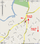
 Google map. Click on the image for a larger version.
|
From the Mass Pike
From The North
From Route 128
From Route 9
From The Mass Pike
-
Take Exit 13; Natick, Wellesley, Route 30.
-
After the tolls, bear left to get onto Route 30 East.
-
Continue on Route 30 for 1.1 miles to the intersection of Route 30 and Route 27.
-
There will be a traffic light at this intersection.
-
There is a Starbucks on your right.
-
Make a left onto Route 27 North.
-
Travel 1.9 miles from that intersection and make a left onto Herland Way.
-
If you get to a traffic light at the intersection of Old Connecticut
Path (aka Route 126) and Route 27, you've gone too far. In that case,
take the left onto Old Connecticut Path,
after 1/4 mile make your first left onto Herland Way.
-
Make a left onto Herland Way. Note, this is a dirt road, go slow.
-
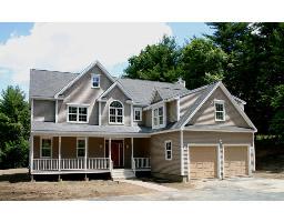
We are the first, and only, house on the right.
From the North
Wayland is approximately 5 miles west of Route 128.
Town center is at the intersection of Routes 27 and 20.
If you are North of Route 20 and close to or east of Route 128,
you can take Route 128 South and follow the directions below.
-
If you are North of Route 20,
but not far enough east to warrant taking Route 128, take the most
appropriate route to the center of Wayland; the traffic light at the
intersection of Routes 20 and 27.
-
From the
intersection of Routes 20 and 27 proceed south on Route 27 1 mile
to your first traffic light at the intersection of Route 27 and
Old Connecticut Path (aka Route 126).
-
Continue south on Route 27 for approximately .3 mile.
Make your first right onto Herland Way.
Note, this is a dirt road, go slow.
-
Our house is the first, and only, house on your right.
From Route 128
-
Take Exit 26, Route 20 West, which is approximately 2 miles north of the Mass Pike.
-
After approximately 3 1/4 miles you will come to a branch where Route 20
continues straight and Old Connecticut Path branches left at about a
30 degree angle. Bear left onto Old Connecticut Path.
-
On your right will be an Exxon Gas station. (This changed to something else recently, Gulf? I keep forgetting to take note!)
-
In the island between Route 20 and Old Connecticut Path is the
Coach Grill Restaurant. Note that the sign for the restaurant is not
very visible though, so don't count on it as a landmark.
-
Travel 1 3/4 miles to a traffic light at the intersection of
Old Connecticut Path (aka Route 126) and Route 27. Make a left onto Route 27.
-
Make your first right onto Herland Way; approximately .3 mile.
Note, this is a dirt road, go slow.
-
Our house is the first, and only, house on your right.
From Route 9
-
Take Route 9 to Route 27
-
Take Route 27 North approximately one mile to Route 30 and continue North.
-
Travel 1.9 miles from the intersection of Routes 27 and 30
and make a left onto Herland Way.
Note, this is a dirt road, go slow.
-
If you pass Herland Way you will come to a traffic light at the intersection
of Old Connecticut Path (aka Route 126) and Route 27.
If you have done that, make a left
onto Old Connectict Path, go approximately 1/4 mile, and make a
left onto Herland Way.
-
Our house is the first, and only, house on your right.

 Google map. Click on the image for a larger version.